


Les allues courchevel Bozel Moûtiers

XavierFaidix
User
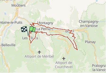

Length
39 km

Max alt
1692 m

Uphill gradient
1801 m
Km-Effort
63 km

Min alt
568 m

Downhill gradient
1795 m
Boucle
Yes
Creation date :
2020-06-23 06:49:22.966
Updated on :
2020-06-23 17:01:02.023
4h00
Difficulty : Difficult

FREE GPS app for hiking
 SityTrail
IGN / Geographical institutes
SityTrail Plus
The world is yours!
About
Trail Mountain bike of 39 km to be discovered at Auvergne-Rhône-Alpes, Savoy, Les Allues. This trail is proposed by XavierFaidix.
Positioning
Country:
France
Region :
Auvergne-Rhône-Alpes
Department/Province :
Savoy
Municipality :
Les Allues
Location:
Unknown
Start:(Dec)
Start:(UTM)
308554 ; 5034147 (32T) N.
Comments